
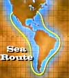
• There were two route choices
o 2,000 mile walk across the barren American outback
o The sea route around the tip of South America
* Took 6 months
* Preferred by gold seekers from eastern states
* Hard conditions (seasickness, food and water problems, etc.)
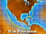
o Sailed as far south as Panama, disembarked, then made 3-day trip by mule and canoe across land to the Pacific side, where they boarded another ship
o Those who did make it to the Pacific were usually stranded.
* Ships to ferry them up the coast to San Francisco were rare, so the forty-niners waited there for months.
o A well-worn path carved out several years earlier by fur trappers
o Used by Americans who lived in Central states
o The overland road much shorter than the sea route, but not faster
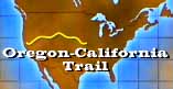
* Went along the Humboldt Basin, The Continental Divide, Independence Rock, Fort Laramie, Platte River, Chimney Rock, Courthouse Rock, and Scotts Bluffs
o As they pushed farther west, there was a fear of Native American Tribes along the trail, but Natives often turned out to be helpful
o The real danger was the lack of water
* Price for water could go up to $100 per drink
o Gold was further inland near Placerville, far from the port of San Francisco where the ships docked.
o Some travelers turned back home after seeing the city of gambling and bars.
o Others took part in experimental travels along the Sacramento River and through the Delta.